Tuesday, November 27, 2012

Lans en Vercors

Lans en Vercors is a cozy mountain town of the department of Isère, Rhône-Alpes region, located in a protected natural area ( Regional park Vercors). Its altitude varies from 1020 m to 1983 m. Lens, Leins, Lans, are variously spelled as established by Cassine maps and Bourdet, was long time the administrative center, located in the hamlet of Peuil, territory named as Quatre Montagnes.
Originally largest village in the valley, Lans is gradually gave the first place to what was a village before: Villard-de-Lans.
This demographic domination original Lans is true in the etymology of the neighboring villages. And Villard-de-Lans literally means "the farm of Lans" and other village Autrans means as "off Lans ", that is to say" beyond the Lans ".
Since May 9, 1947, Lans took its current name Lans-en-Vercors.
Today Lans-en-Vercors is a quiet village but with dynamic hosting; each summer season having sport or cultural events. And in August 2008 was held the fourth European Congress of Speleology, in the largest gathering VERCORS 2008, organized by the French Federation of Speleology and caving Federation of the European Union.

Currently Lans-en-Vercors has population of  2 684 people, to compare with population in Villard de Lans of 4 277 people in 2012.  
Lans en Vercors has: two downhill ski areas: Les montagnes de Lans and le Massif de l'Aigle and also two areas of cross-country skiing: Les Alliéres and Le Val-de-Lans.

Monday, October 29, 2012

Snow in autumn(29.10.2012)

This year snow came so unexpected, it was about 1 meter deep in Villard de Lans area, after one night of snowfall.  Probably it be will melted very soon, but for the moment we enjoyed the sun and snow!


Tuesday, October 9, 2012

Golden autumn in Vercors

When golden autumn coming to the Vercors, standing on the mountain top, you can see amazing sceneries when all the forest leaves are changed into gold and red colors. 
"Autumn is a second spring when every leaf is a flower".  ~Albert Camus


Sunday, September 30, 2012

Festiv'Air - Villard de Lans


Villard-de-Lans, in the department of Isère,  organizes every year a big party of the air balloons - Festiv'air. This year festival was celebrating its 5th edition on 29 and 30 September 2012.  
Many activities for the families were available:
- A collection of more than 20 balloons
- Flight demonstrations of mini balloons
- Shows kites of the world (Indonesia, Japan, Europe)
- Release Brazilian balloons
- A wind garden
- Workshops to build kites
- Introductory workshops about the paragliding
In addition was planned the grand spectacle of balloons, this edition would be the first time of an airship above the village. But, unfortunately, this year, the weather conditions were too bad for this spectacle. So only friday evening, day before festival, was possible to see some of the balloons above the village.


 And more photos:

Friday, September 28, 2012

Monday, September 24, 2012

La Petite Moucherolle

Grand and Petite Moucherolles
Petite Moucherolle ( 2156m) is located just near Grand Moucherolle (2284m). It is more visible from the south side, the village Corrençon en Vercors. 
Today topic is dedicated to the itinerary from the Corrençon village till Petite Moucherolle.
The route started from the ski resort point "Clos de la Baume", which is located at the altitude of 1230 m. 


    The itenerary time is about 2.5 - 3 hours, one direction. It is better to take this road when the weather is good and dry, as stones and ground could be slidy, making the climbing up too difficult. The gain is quite similar during all the way, just at the end of the way it is became a little bit difficult.

 
Way to Petite Moucherolle marked with the black


Thursday, September 20, 2012

Video of the day


The best video about the Vercors, mountain activities and the nature..Enjoy it!


Saturday, September 15, 2012

Col de Rousset

     The Col de Rousset is located in the heart of the Vercors and its altitude varies from 1254 to 1700 meters in the winter and in the summer from 1255 to 2341 meters (Grand Veymont). Col de Rousset belongs to the  Drôme department, the village of Rousset on which the col belongs to, is the municipality of Saint-Agnan-en-Vercors. It allows to access to another department -Die through a tunnel located at 1254 meters altitude and  which having a length of 769 m. Col de Rousset is more popular place for many cyclists and hikers in the summer than skiers for the winter time. 


You can also have special climbing places for very beginners.


Tuesday, September 4, 2012

Lakes: Lac de la Moucherolle & Lac du Pré

 Lake du Pré is located at the altitude of 1536 m and is the closest to the ski station Cote2000. It's takes about 20 minutes by taking the telecabin Cote 2000, or 1 hour walk from the Glovettes. The lake surface is about 0,01 square kilometers and 8m deep. It is strictly forbidden to swim here.


Lake de la Moucherolle is situated at an altitude of 1916m, just at the foot of the pic "Grand Moucherolle". It is accessible in 120 minutes from the arrival station of the telecabin Cote 2000, or about 3 hours from the bottom station of Cote2000. The surface of the lake is about 0.02 square kilometres, 12m deep and full of fish. It is forbidden to swim here, but allowed to fish. 

Sunday, September 2, 2012

Photos from this weekend

Following direction Le Chambaran & Malleval en Vercors, can meet during the way very nice landscapes..

Saturday, September 1, 2012

Fog,fog..so scary and amazing

Morning  fog over the Vercors plateau is quite common weather condition during all the year. Fog can form so suddenly, and can dissipate just as rapidly, depending on the temperature and wind. Fog is like a playground of imagination. Eyes can seem to play tricks on us when we can imagine seeing things just beyond our visibility that frighten us. 
Enjoy some amazing photos of the fog over the mountains and forests in Vercors.

Friday, August 31, 2012

Photo of the day

So early autumn this year, just 31 august, but already so much different colors..
Cote2000


Thursday, August 30, 2012

The Regional Natural Park of Vercors: territory, seven regions.


Exceptional diversity of Vercors, which distinguishes it from other pre-Alpine mountains, is illustrated in the seven natural regions which compose it: the Four Mountains in the north, in the northwest- Coulmes, in the west -Royans, center Vercors -Drome, in the east- Trièves, southeast -Diois and in the Southwest- Gervanne.

Regions in the Vercors Regional Park
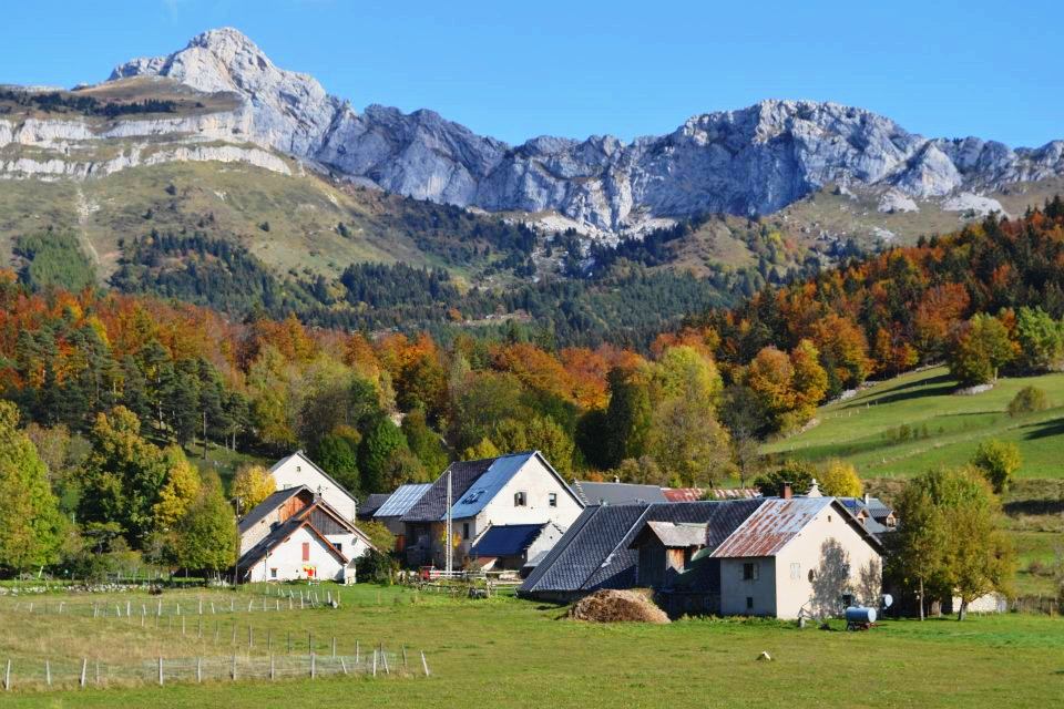
  Quatre Montagnes

The Northern Plateaus of Vercors are also named the "Quatre Montagnes" that can be literally translated in "the Four mountains". The valleys lined with cliffs and rocky outcrops, this northern region of Vercors is dominated by Grenoble urban area, the valley of the Isère and Drac. It was developed with the mountain agriculture, forestry and tourism development of Climatotherapy, then later stations of Nordic and Alpine skiing.

The Coulmes

This most forested massif which devided regions of Royans and Drome by deep gorgesde la Bourne”. This is the least populated region of Vercors.

The Royans

This region extends from the area of the Isère to the plateas and penetrates the Vercors by impressive gorges. Dominated by plateaus: “Ambel” and “Font D'Urle”, partly covered by the vast forest “de Lente”. Situating on the hills, Royans has a mild and pleasant climate, conducive to walnut plantations. Three of the impressive vercors gorges are in this area: Combe Laval, the Grand Goulets and the Bourne gorge. The Choranche caves (Grottes de Choranche), with rare and impressive speleothems are also situated here.
Combe Laval
Vercors Drômois

Vercors Drôme region is also called"
The Western plateaus" is authentic area, where agricultural activities are shaped to an open and green landscapes. Together with the high plateaus, they are what was first named "Vercors", before it became the name of the whole massif.

Trièves

Located in the foothills of the Vercors ,the Trièves is stuck between the cliffs of the Vercors. This isolate it from the rest of the massif and the deep valley of the Drac. Trièves is famous with one of the seven wonders of the Dauphiné – le Mont Aiquille(2086m).

Wednesday, August 29, 2012

Vercors, beautiful country.


Vercors, like a stone ship, stands in the middle of the valleys and three rivers are surrounding it: the Drac in the east, Isére in the west and Drôme in the south.

Its Altitude varies from 180 m of the river Isère to 2341 m at the top of the Grand Veymont.  
This is a beautiful and unique countryside with diversity of landscapes and environments that has amazing flora and fauna of moutains. 


 But what about its climate?


North-South Climate

At the passage between the Northern Alps and the Southern Alps, the Vercors is the subject of three climatic influences : altitude, rainfall and ocean Mediterranean regimes.

It is the tight interplay of these influences, but also relief that largely explains the exceptional botanical richness of the massif. Rainfall is also characterized by great disparities: maximum of 1649 mm for 133 days per year on average western edge against 880 mm for 89 days on the southern edge.

So beautiful nature!


In this post we would like to introduce nice and beautiful nature of Vercors. 
There is so much beauty all around us to see. 
Nature is the miracle; it is changing so fast that sometimes something you look could be completely different next time. 
Enjoy it!


Tuesday, August 28, 2012

Vercors Treasure Island


Located at mid-mountain, the Vercors aspects high mountain especially in the eastern part,which is also called "French Dolomites". It is also characterized by large areas with undulating hills and tormented its highlands in the southeast and its large pastures in the southwest.

For 10 million years, glaciers, water and snow have eroded, carved embossed tone and thy Urgonian limestone erected in a parade of walls turned Vercors into a citadel.

A period of global warming, ice made large holes which, for over a century, have become the spectacular gorges access the mass of Vercors.
Inside the great plateax its long valleys and vast forest
have always offered the strangers the shelter and substenance.

"Vertacomocorii" the members of a Celtic tribe from the north, settled on the plates 600 years before our era and are the origin of name "Vercors"

Land of liberty, Vercors have gathered the largest underground French resistance during World War II. Its become a "High-rise Memory."

Haven and Foodland, people have shaped its agricultural land and forest alive. And are thus in 1970, through their will, was created  the" Parc Naturel Regional du Vercors", to promote sustainable development policy on Vercors territory.

"Vercors" you are the Treasure Island! 
Col Vert of Vercors


Welcome to our blog!

Hello,
The goal of this blog is to share with everyone our life in the mountains.
 Here follows a little introduction, what is Vercors and where it is.
The Vercors is a range of plateaux and mountains in France, that situated in the departements of Isère ( 38) and Drôme(26) in the French Prealps.